Challenge

Digital Twins can help mitigate flood risk, but are hard to deploy in all geographical circumstances

Hundreds of millions of people around the world are at risk of flooding from the sea, from rivers or as a result of extreme rainfall. Every year, there are thousands of casualties and extensive damage. Population growth, economic development and climate change mean these numbers will continue to increase in the future.

It is impossible to completely prevent floods, but Digital Twins can help make countries and regions less vulnerable to flooding by acquiring more knowledge in the fields of protection, dike failure mechanisms, better quantification of risks, developing sustainable and effective solutions (such as flood risk management landscapes) and developing forecasting and warning systems. In this way, we can contribute to making the world safer for floods at an acceptable cost.

FloodAdapt, developed by Deltares, is a digital twin that seeks to advance and accelerate flooding-related adaptation planning. It brings rapid, physics-based compound flood modelling and detailed impact modelling into an easy-to-use system, allowing non-expert end-users to evaluate a wide variety of compound events, future conditions, and adaptation options in minutes. FloodAdapt serves as a connector between scientific advances and practitioner needs, improving and increasing the uptake and impact of adaptation research and development.

However, deploying FloodAdapt for any geographical region of interest, requires that complex compound flood models are set up and integrated with hydrological models, impact assessment tools and the necessary local and global data. Developing and validating such models can be a time-consuming task, even for expert users.
Solution

Facilitating the worldwide deployment of the FloodAdapt Digital Twin

In interTwin, we are developing the necessary thematic and core modules of the Digital Twin Engine (DTE) that will enable a digital twin builder to easily set up FloodAdapt as a Digital Twin anywhere on Earth.

This will empower communities to make informed flood risk mitigation and adaptation plans.

Thanks to the work being done in the interTwin project, developers will be able to easily build a digital twin for compound flood modelling, using the Digital Twin Engine on a federated computing and data infrastructure. The process involves configuring, executing, and validating the digital twin, while also ensuring efficient collaboration and version control.

In turn, decision makers will be able to effectively use the output from a digital twin to make informed decisions, either by exploring pre-built visualisations and data analytics through an online dashboard or by developing custom analyses

FloodAdapt strives to accelerate equitable adaptation planning by making the latest innovations in compound flood and impact analysis accessible to decision-makers. The automated workflows supported by the interTwin Digital Twin Engine allow users without a modeling background to specify what-if scenarios - historic or synthetic weather events, future climate and socio-economic projections, and adaptation options – and to visualize and evaluate the simulated flooding and impacts in their communities.

Dr. Kathryn Roscoe (Deltares, Flood Risk and Adaptation Specialist, Product Manager of FloodAdapt)

Deltares is providing and further developing the necessary thematic components enabling:
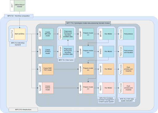
    1. Model building: Setting up a model schematisation (grid) for a user defined area of interest for the required hydrological and flood inundation models and impact assessment tools
    2. Preprocess boundary condition data: Preprocess the dynamic data to the format  needed by the models for boundary conditions
    3. Running the models: Docker and Singularity containers to run the models on heterogeneous compute and data infrastructures
    4. Postprocessing the output data: Postprocessing the output data from the models for visualisation and analysis interfaces.

Proposed workflow:

  • Hydro Model Tools (HydroMT) is used to set up the necessary models and tools for a user defined geographic area of interest
  • HydroMT will create model schematisations for Super-Fast INundation of CoastS (SFINCS), a hydrological model (wflow), Fast Impact Assessment Tool (Delft-FIAT) and a Resilience Assessment and Adaptation for Critical infrastructurE Toolkit (RA2CE)
  • SFINCS and wflow provide flood maps of a flood event to Delft-FIAT and RA2CE
  • The flood maps will be augmented with a flood map from the Global Flood Monitor provided by TUWien which will be used by Delft-FIAT and RA2CE to calculate impact on building, utilities, roads and accessibility.

The thematic modules will leverage capabilities from core modules of the Digital Twin Engine, including workflow composition and execution capabilities, data fusion functionality, container workload management and batch queueing systems and FAIR data quality evaluation capabilities.

Deploying the FloodAdapt Backend

A developer can easily build a digital twin for compound flood modelling using the Digital Twin Engine on a federated computing and data infrastructure. The process involves configuring, executing, and validating the digital twin, while also ensuring efficient collaboration and version control.
1. Access the federated infrastructure through harmonized interfaces.
+

The user logs into the federated computing and data infrastructure using the appropriate credentials and command line interface (CLI), such as SSH

2. Load required modules and dependencies
+

The user loads any necessary modules or libraries required for the Digital Twin Engine, such as programming languages (e.g., Python, R, or Julia), geospatial libraries (e.g., GDAL, Proj), or specific Digital Twin Engine modules

3. Clone the Digital Twin Engine repository
+

The user clones the Digital Twin Engine’s open-source repository to the local federated infrastructure environment, ensuring they have the latest version of the platform and its components

4. Configure the Digital Twin
+

 The user customises the configuration files for the compound flood modelling digital twin, including specifying data sources, model parameters, and output formats. This may involve editing text-based configuration files, JSON files, or other formats supported by the Digital Twin Engine

5. Integrate application-specific components
+

 The user integrates any application-specific digital twin components, such as custom hydrodynamic models or data preprocessing scripts, by adding them to the appropriate directories and updating the configuration files as needed

6. Execute the Digital Twin Engine 
+

Using the command line interface, the user executes the Digital Twin Engine with the specified configuration, running the compound flood modelling digital twin. This may involve running a series of scripts or executing a single command, depending on the design of the Digital Twin Engine

7.Monitor progress and troubleshoot
+

The user monitors the progress of the digital twin execution through the command line interface, examining log files and console output for any errors or warnings. If issues arise, the user may need to modify the configuration files, update the application-specific components, or adjust the federated infrastructure resources to resolve the problem

8. Validate the digital twin output
+

After the digital twin has completed execution, the user validates the output data to ensure the compound flood modelling results are accurate and consistent with the intended design. This may involve comparing the digital twin outputs to observed data, performing sensitivity analyses, or examining summary statistics

9. Version control and documentation
+

The user maintains version control for the Digital Twin Engine and its components, using a system such as Git, and updates any relevant documentation to reflect the implemented changes and improvements

10. Share and collaborate
+

The user shares the digital twin with other researchers, stakeholders, or collaborators by providing access to the federated infrastructure, distributing the configuration files, or sharing the digital twin components through an online repository

Benefits for Decision Makers

Decision-makers will benefit from the backend deployment of FloodAdapt

A rapid and streamlined deployment of the FloodAdapt backend – made possible with the Intertwin DTE – benefits decision-makers by making it faster and cheaper to obtain a FloodAdapt system for specific community (using the front-end Graphical User Interface (GUI) that connects with the FloodAdapt backend developed with Intertwin DTE). Once the FloodAdapt system is in place, they can evaluate floodings and their impacts for user-defined what-if scenarios, to help support their decision-making process, and to engage community members.

How does it work?

1

Specify area of interest

Allow a Digital Twin developer / implementer to specify an area of interest

3

Produce Flood Maps

Run WFLOW and SFINCS to produce flood maps, which will be augmented with Earth-Observation-based flood maps that represent a part of the Global Flood Monitoring processing chain of the Copernicus Emergency Mapping Service (CEMS)

4

Impact prediction

Post-process the flood maps to create deterministic and probabilistic flood maps and serve these as input data for Delft-FIAT and RA2CE which determine the impact of the flood on buildings, utilities, roads and accessibility.

5

Visualisation and Analysis

Post-process the data for visualisation and analysis (e.g. Jupyter Notebooks)

6

What if?

For FloodAdapt climate impact, the user will be able to define mitigation measures or what-if scenarios and rerun the simulations to e.g. understand the impact of building flood protection in specific areas, or understand the impact of a scenario where twice the amount of rainfall occurs.

Floodadapt would like to thank David Alexander from the US Department of Homeland Security, whose vision (and financial support) facilitated the creation of FloodAdapt.